Portland Urban Hike: Northwest

Last night, we stayed with my friend Heather, whose positive attitude turned around our day. We had dinner on what she called “Trendy-third street” (NW 23rd) where I actually chose not to get Salt & Straw Ice cream because the line was curled around the door—even at 9 pm in the rain on a Wednesday.

To make up for lost miles yesterday, we started earlier and hit the Washington Park stairs and those in the neighborhood. Our plans were stymied when a trail that led down to the Japanese Gardens was closed for construction related to the gardens, so we had to take surface streets there.

The sun was perfect and Virgo was having a field day filming in the park. We started on the official map for Day 9 around 9:30—the same time we’ve been generally starting each day after I finish my morning work.
From here, we hit up the classic Northwest Hills stairs. This are big stairs in beautiful neighborhoods. They are the kind of public stairs I love and am familiar with from other cities—take a big hill, put a grid on it, have every road deadend with a public stairway up to the top of the ridge.

After breakfast, we met up with our friend Carrie, who lives in the area and would run the stairs for training during her lunch break. It was fun using the map to show her a few new stairs—including on the strangely named Circus (yes, Circus is used as the directive instead of ‘Street’ or “Rd” or “Way” or “Ave”)
Despite the previously bluebird sky, it rained and rained hard for a good ten minutes as we entered Forest Park on the muddy and super steep Holman Trail. It was SUCH a respite to be in the peaceful park and just put one foot in front of the other.
That was—until it spit us out at the curvy, high speed, no shoulder 53rd Ave. We walked down to the even scarier Cornell Road near the Bird Sanctuary until veering off at the Collins Trailhead.
This was one of those days where everything works out. According to Google Maps, there are no trails that connect the Bird Sanctuary down to Skyline Drive except the Wildwood (which I am saving for Saturday and goes way out of the way). It looks like there is private property south of the Bird Sanctuary. But some sleuthing, looking and topo maps, and hiking forum searches turned up a little visited trail owed by the Bird Sanctuary that connects them all—the Collins Trail.

I wasn’t sure if it’d work and the intersection we ended up veering off on was for an unmarked trail, but it ended up leading exactly to where we wanted. We were spit out in the neighborhood far south that we needed—except there was a big gate separating us from the neighborhood. It looked like we were urban cliffed out behind private property. We reinvestigated, and the gate is to prevent people from the neighborhood from driving to the a water pump area, not to prevent pedestrians from accessing from either side.

The Meriden Ridge neighborhood boasts the newest stairs in Portland—long, never ending stairs up practically up to the OPB radio tower near Skyline Blvd. The houses in this neighborhood were ridiculously large. But that’s one thing I love about urban hiking and the sometimes seemingly foolish persuit of stairs—it forces you into neighborhoods you would never go. Where the wealthy may be inclined to think of public roads and public sidewalks as amenities of their own enclave of the wealthy—to start thinking of the neighborhood as an exclusive not-gated community—there was still public resources used there. The road and sidewalks and stairs there are built with public funds for everyone’s use, so it’s important that pedestrians go there to visit.
The walk down Skyline Blvd to Burnside was scary and fittingly hugged a cemetery. It was a relief to veer off into a neighborhood and take 58th Ave all the way down to US 26. After a long lunch, we braced ourselves for the fate we had ahead: walking Scholls Ferry Road.
Scholls Ferry Road has no shoulder, no bike lane, and twists and turns as cars go quickly down hill. There are no connector alternates from US 26 south that would work otherwise. Googlemaps said it was the best bike route simply because it’s the only route in that area. The road made me so mad—that for millennia, people have been able to access all sorts of places with our feet and hands and only relatively recently in history have we built these places where feet and hands do us little good in the face of large machines.

We finally veered off into a neighborhood and it was like night and day. We actually made jokes about how we had been hit by cars and gone to the urban thru-hiking afterlife: the road was carless, wide, downhill, with lots of sun, and there were flowers everywhere. It was so beautiful—especially in contrast to Scholl’s Ferry Road—that it was hard to imagine that the two places were so close to one another.
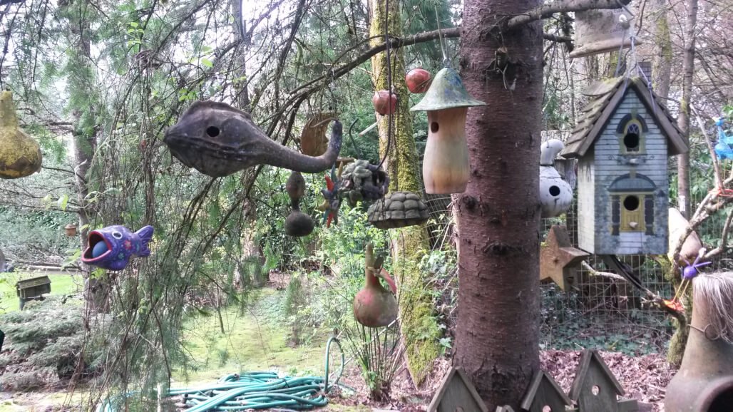
The rest of the day was a fun series of hidden stairs, alleys, and pedestrians paths signed by the SW Trails Association. We frequently saw the numbered SW Trails signs again. An AT hiker, Prefontaine, came and joined us for the last pleasant bit to Multonomah Village. It was fun to see what these locals described as “old Portland” or “90s Portland”—fun art, colorful yards, a little hippie in a Pacific Northwest kind of way.

From Multonomah Village, Prefontaine drove us to Next Adventure where I gave a talk on urban hiking and about my hike so far. It was a fun crowd of mostly thru-hikers, but there were a few people who were thru-hiking aspirationals who told me afterwards how inspiring the talk was. We stayed up late talking trail and gear. Day 9 was a varied day—a day of extremes—but that’s always been what I love about thru-hiking, whether in the mountains or in the city.